In the era of climate change, the ability to model and predict the future ocean is essential for policy making and to inform business decisions. Kiel's marine scientists, including mathematicians, computer modellers and oceanographers, play a key role in this vital interdisciplinary project. The Kiel Climate Model is their unique tool for calculating interactions between the ocean, the atmosphere, sea ice, and ocean biology and chemistry.
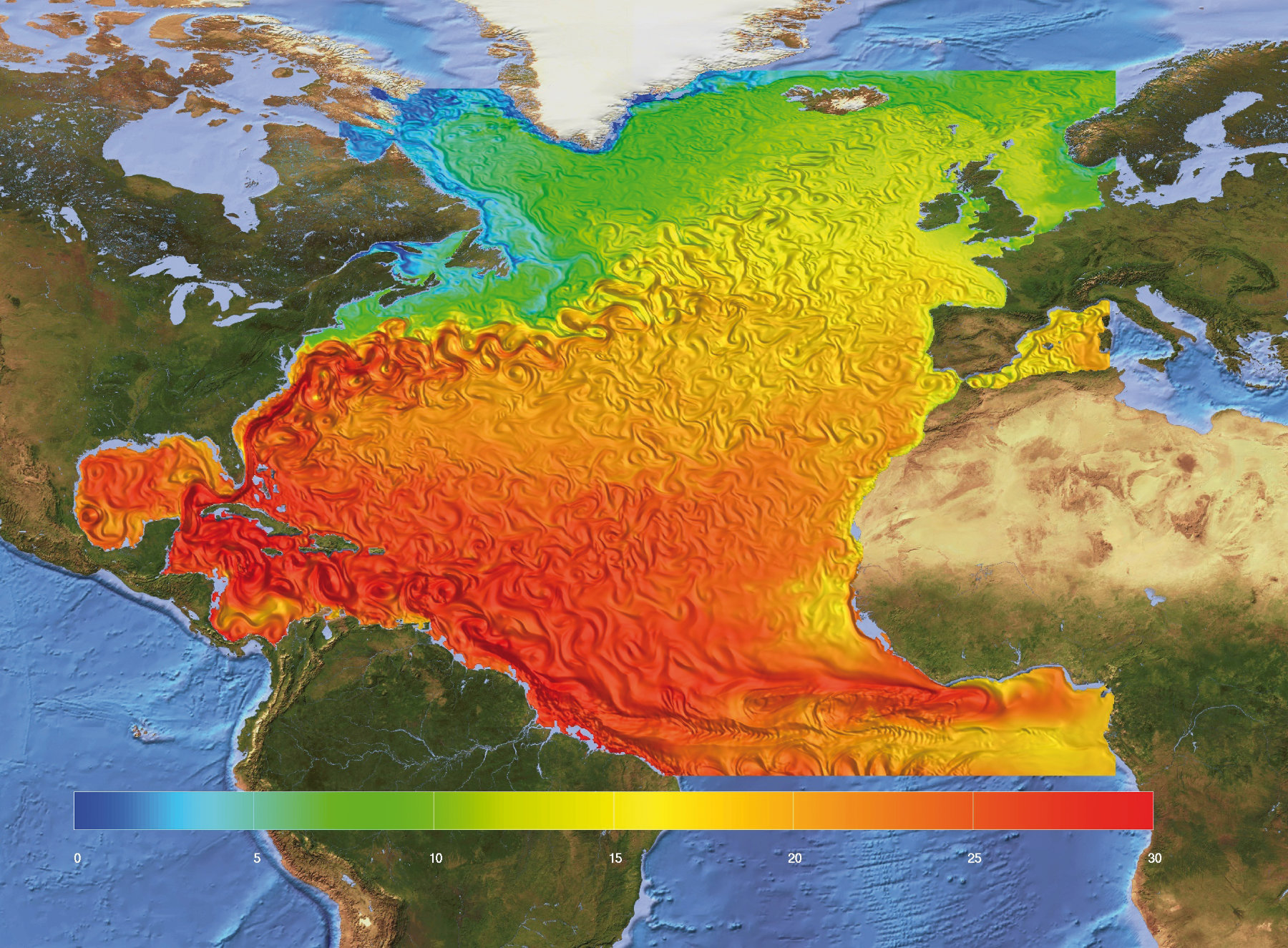
While its work is global, Kiel marine research has traditionally been strong in improving climate models for the North Atlantic area, and has created improved simulations of the ocean current regime in this important ocean region. In 2016, a group of three Kiel researchers led by Mojib Latif published the solution to a long-standing problem with models of the North Atlantic [1]. Sea-surface temperatures predicted by previous models were inaccurate, because they did not have good information on the salinity of the topmost layers of the ocean. These models had used values that were too low for key areas of the northern North Atlantic and the Arctic Ocean. So they have not incorporated as much mixing of surface and deep waters as happens in reality. This leads to misleading results, like predictions of too much sea ice.
The Kiel scientists ran a number of different versions of the Kiel model to see what happens when the sea-surface salinity is corrected by the use of improved climatological data. This approach led to a more realistic model of the ocean's convection, which in turn led to better models of the sea's surface temperature. These better models will permit improved predictions of short and long-term climate variation in Europe, both natural and anthropogenic.
Can computer models help us to understand the ocean? How precisely can we reconstruct ocean currents and vertical mixing? Will ocean currents change in the future? Is it possible to run ocean models backwards?
The more we learn about the ocean system, the better our educated guess on the future will be. Our improved understanding of natural phenomena, and refined environmental data, allow better calculations of the effects of climate change. The ocean's current system will most likely change in the future. The latest computing technology is required if we are to model change in a way that is valuable to human society.

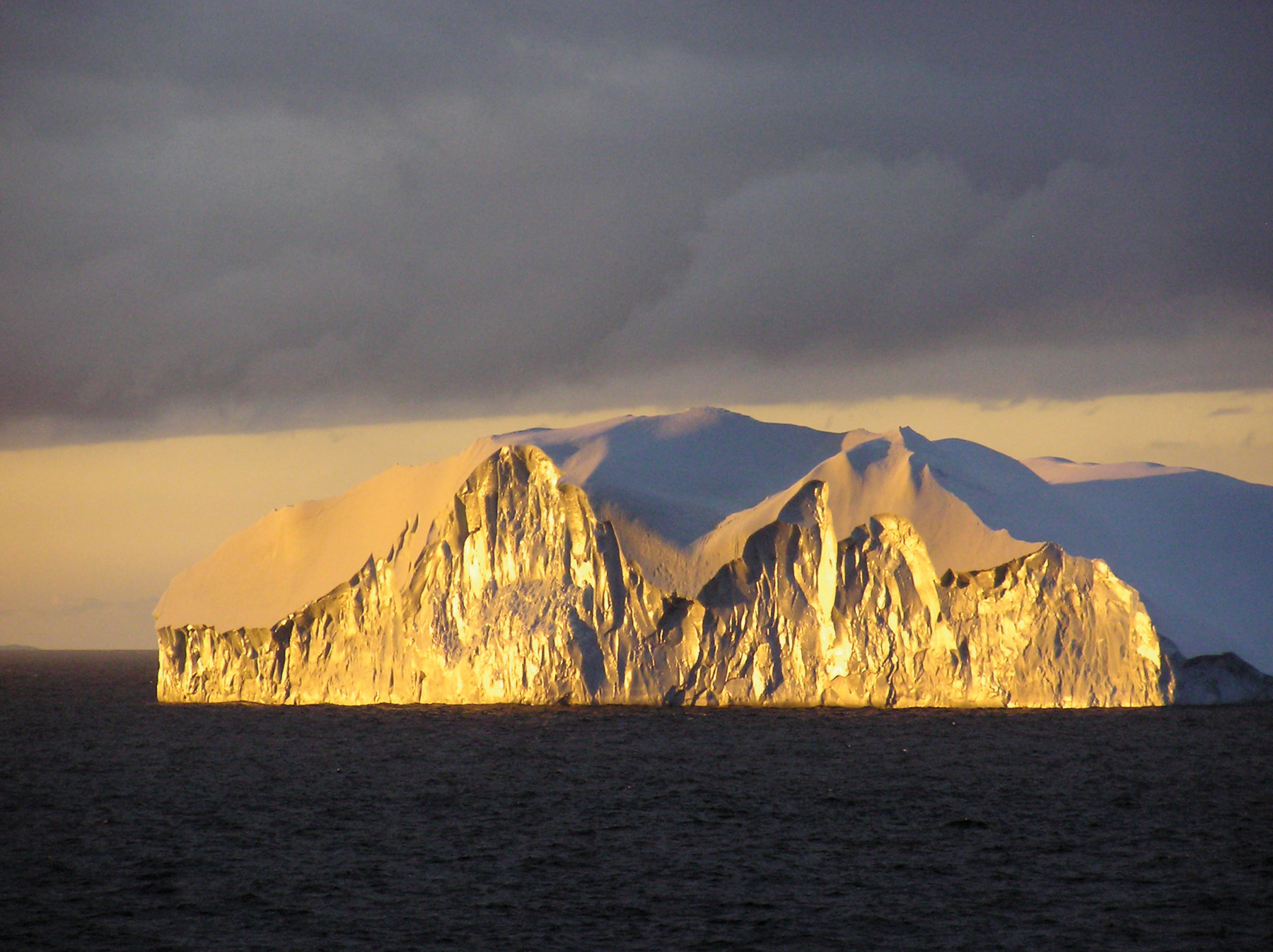
Greenland loses ice
Kiel research is also directly relevant to one of the most-discussed aspects of human-induced climate change, the possible destruction of Greenland's immense glaciers and its effect on the Atlantic meridional overturning circulation or AMOC. Oceanographers are very concerned with the effects of melting ice on ocean currents.
Working with colleagues from the UK, Kiel researchers including Claus Böning and Arne Biastoch (both GEOMAR) have modelled the impact on the ocean circulation of the growing mass loss from the ice sheets of Greenland, which has been observed since the 1990s [2]. Nearby regions of the Atlantic have been affected by a growing flux of fresh water. As this cold, fresh water reaches the Atlantic, it could concentrate in the upper reaches of the ocean and weaken ocean convection in the Labrador Sea and the Atlantic. Some bleak forecasts suggest that this effect could slow the AMOC and therefore the Gulf Stream's journey from the Gulf of Mexico to the north-East Atlantic, and drastically reduce winter temperatures in continental Europe.
The Kiel modellers have assessed the impact of these increased flows of fresh water, using a global ocean circulation model with a grid spacing fine enough to capture the small-scale, eddying transport processes in the subpolar North Atlantic. This modelling suggests that so far, the invasion of meltwater from the ice sheets of West Greenland has had only a limited effect in the Labrador Sea. The effect so far is smaller than the region's natural variability. However, big episodes of natural freshwater melting are known from 1970, the mid-1980s and the early 1990s. It seems that each of these events involved about 1700 cubic kilometres of fresh water making its way from the Arctic to the North Atlantic. This is a massive amount, about equal to a cube of water measuring 12km on each side. The Kiel group says: "Our model simulation suggests that the accumulation of meltwater in the Labrador Sea is reaching half that magnitude."
At the moment, they say, we are observing only minor repercussions of this increased runoff. Their models suggest the "first hint of a weak signal" in Atlantic currents and convection patterns. But they add that a much larger melting effect of 3,000 cubic kilometres per year would cause a rapid dilution of the surface waters, an end to deep convection of the ocean after six to eight years, and a rapid slowdown of the AMOC. They say: "Under a continuation of the actual observed trend, (an effect of this) magnitude would be reached around 2040." And they add that the normal variation in the behaviour of the Atlantic is so big that it could cancel and hide this trend until it was nearly upon us.
As computational power increases and data-gathering improves, model calculations become better and better. Current ocean and climate models already help us to understand the scale of the influences on the Earth's climate. The example of the Agulhas Current proves that we can now refine our models to an unprecedented level of detail.
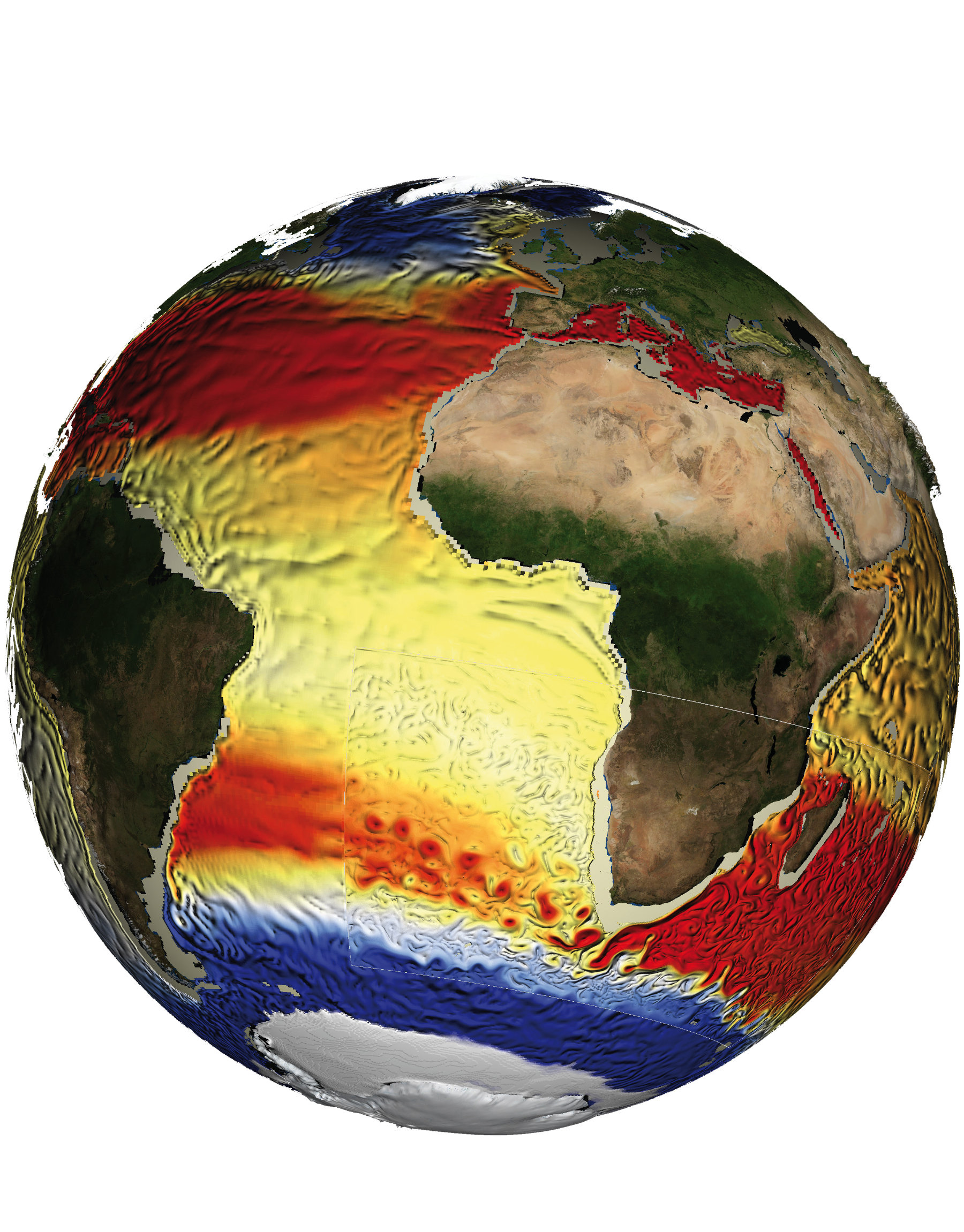
Agulhas Influence
Kiel modellers are also unravelling the complex flows of water and heat at the other end of the Atlantic. Here warm, salty water is carried from the Indian Ocean to the Atlantic by the so-called Agulhas leakage, an extension of the Agulhas Current in the Indian Ocean around the southern tip of Africa. The water that Agulhas leakage brings to the Atlantic could not be more different from the cold, pure meltwater of Greenland. But it too could be an indicator of human-made climate change. Kiel modellers have worked on its possible future evolution, in a large international collaboration effort [5].
They find that the previously disregarded Agulhas leakage is "a crucial component of the climate system" and that "ongoing increases in leakage under anthropogenic warming could strengthen the Atlantic Overturning Circulation." While Kiel research on ice loss in Greenland suggests that this vital feature of global ocean circulation is threatened by the arrival of large volumes of cold water in the Arctic, it also indicates that injecting warm, salty water to the South would add to its strength.
This research is not all about the ocean. The Agulhas leakage is also influenced by prevailing winds. Current models suggest that the westerly winds observed in the region will move south under conditions of global warming. If so, they change Agulhas leakage and the amount of warm and salty Indian Ocean water entering the Atlantic from the south. The researchers say that it is already possible to observe a trend towards increasing Agulhas leakage consistent with the observed increasing intensity of the westerly winds over the past three decades. It is "projected to continue over the 21st century" as a result of anthropogenic climate change [6].
Tracing the migration paths of juvenile turtles along ocean currents
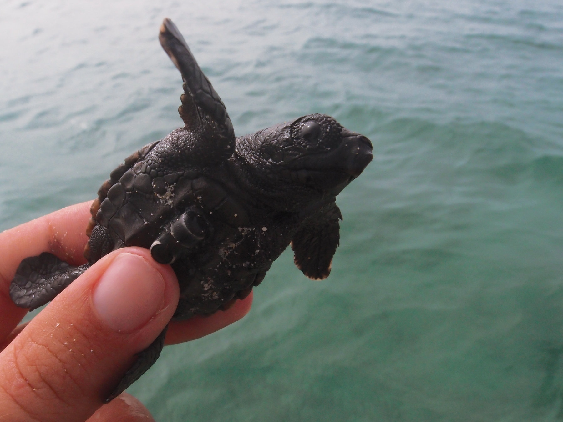
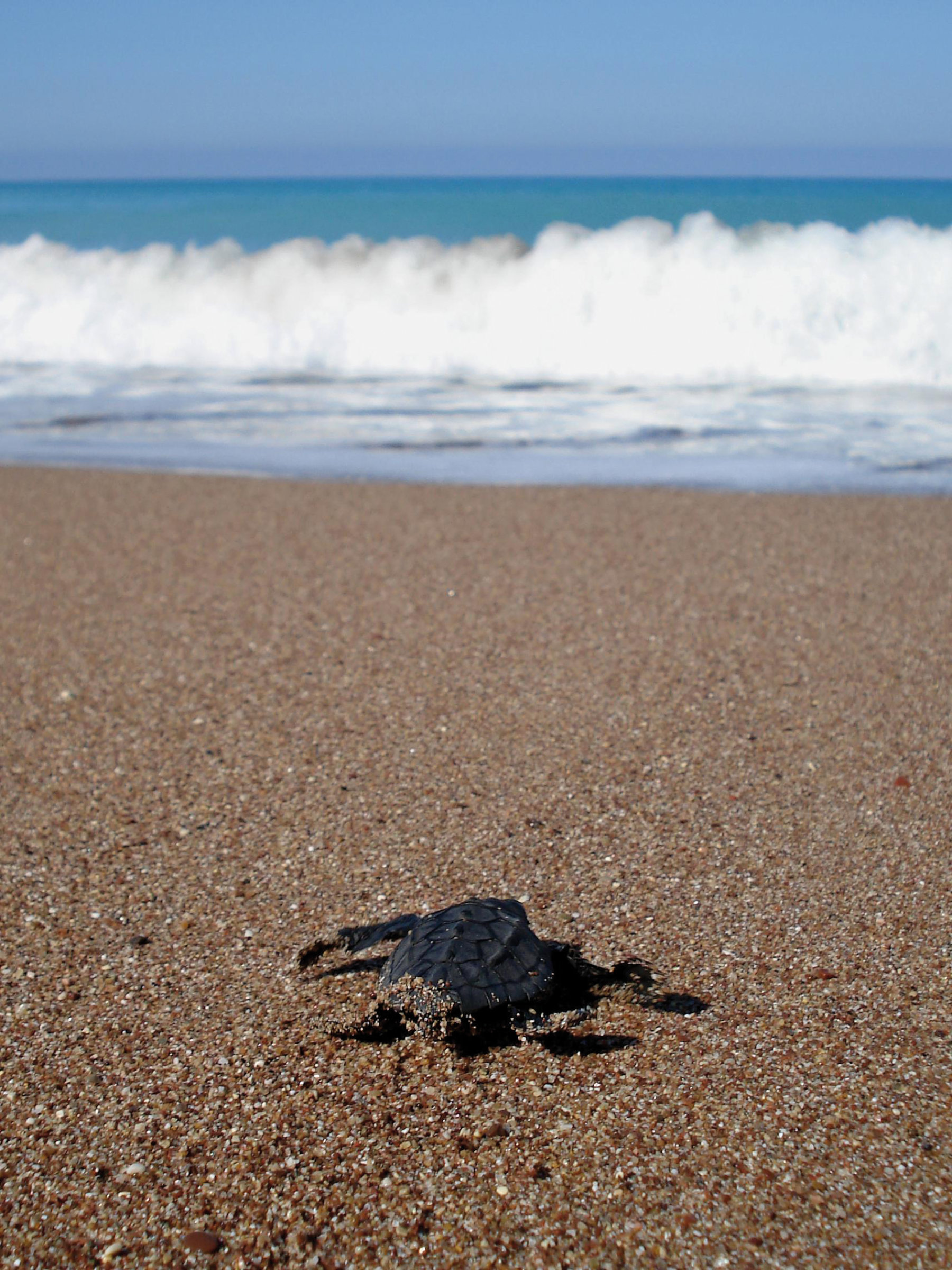
Data about the ocean is not gathered only from buoys, aircraft, ships and satellites. New technology means that we can learn about the ocean from the movement of ever-smaller animals. Kiel scientist Rebecca Scott has been attaching "nanotags" to new-born loggerhead turtles in Boa Vista, one of the Cape Verde islands, in collaboration with colleagues from Cape Verde and London. The newly-hatched turtles are only a few centimetres in size, and it has not been feasible before now to attach such tracking devices to them. This work has shown that the turtles, which hurry into the sea as soon as they hatch, can cover 15km of ocean during their first few hours of independent life. They use sea currents to travel at up to 60m per minute. It seems that bigger turtles swim more than smaller ones, and that the turtles' behaviour is adapted to local ocean conditions. Scott says that many turtle species such as the loggerhead are endangered or threatened. So this research helps design the right strategy for their conservation. She adds that up to now, we have had little awareness of their early life. As she puts it: "Technology is now emerging to allow this crucial lost phase of life to be studied." This research has shown that once they are at sea, the loggerhead turtles' movement is determined largely by ocean currents. Boa Vista is close to major surface currents, and the turtles there have less far to swim to reach them than turtles in Florida, also a major population centre for these animals. This means that the Cape Verde turtles can become inactive at night at an earlier age, allowing them to be less obvious to predators [3]. This research allows scientists to improve their knowledge of ocean circulation patterns and to learn about the behaviour of animals whose conservation is a matter of environmental concern. In a new and highly innovative study in Gabon, behavioural studies of hatchling turtles are now being combined with in-situ observations of ocean currents. "These in-situ observations, collected using novel turtle inspired surface oceanic drifters, enable us to accurately assess the swimming behaviours of hatchlings whilst improving our understanding of upper surface processes" says Rebecca Scott. "Hatchling turtles actually experience, and have evolved to respond, to very fine scale ocean variability, which models are too coarse to resolve." In-situ studies of this nature on young turtles can provide valuable new high-resolution ocean current data to test the robustness of ocean models.
The hunt for MH370
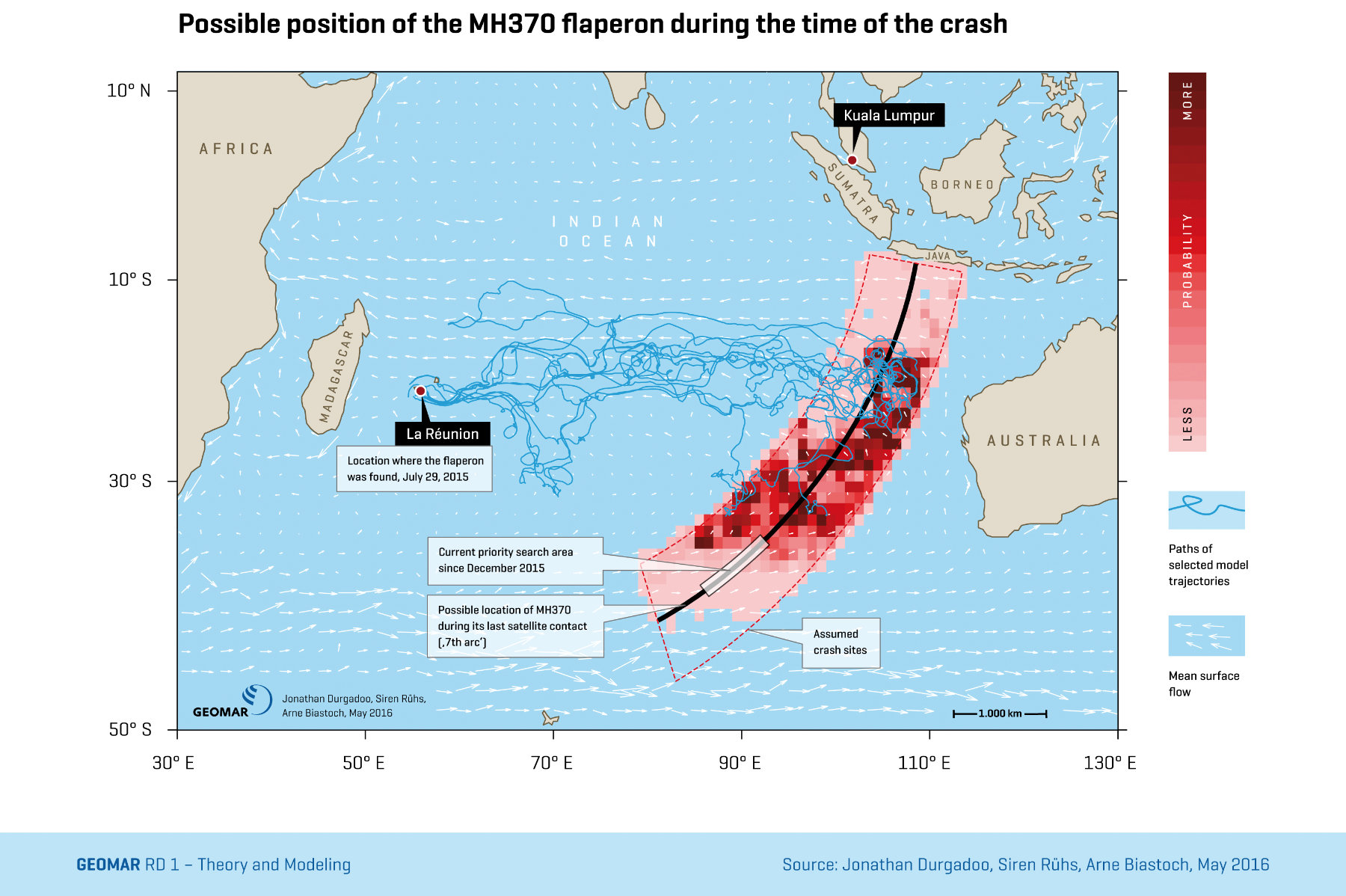
On 8 March 2014, Malaysia Airlines flight MH370 from Kuala Lumpur to Beijing vanished over the South China Sea. None of the 239 people on board have been seen since that day. The search for wreckage continued for almost three years until January 2017, but has now been terminated without a definite result.
However, our knowledge of the circulation of the Indian Ocean has allowed Kiel scientists to play a role in the hunt for the truth on MH370, and to draw radically different findings from those of other investigators. It seemed likely that the aircraft had headed south-west over the Indian ocean before it crashed even before the search. The first definite wreckage from MH370, a component called a "flaperon," was found on the shores of La Réunion, a French island in the Indian Ocean, in July 2015. More pieces have since been found on the coastline of the African mainland. Working with scientists from France and the UK, Kiel researchers have used results from ocean and wave models, which incorporate observational data, to analyse the route that the La Réunion fragment might have taken whilst afloat [4]. They did this through a computer model in which they released about five million 'virtual flaperons' around La Réunion and computed their trajectories back in time. This allowed them to calculate the probable point of origin of the flaperon at the time when MH370 vanished even before the search. The calculations have also been refined by the addition of physical processes which simulate movement at sea more realistically, such as drift induced by wind-generated ocean waves. Jonathan Durgadoo of Kiel says that this study shows that the flaperon probably entered the ocean "in a region north of the main search area for 2016."
His colleague Arne Biastoch (GEOMAR) adds that this finding has been strengthened by the discovery of further debris at other locations in the southwestern Indian Ocean. "The ocean currents through the Mozambique Channel and along the South African coast are extensions of the route that passes by Réunion," he says. The Australian authorities leading the search for MH370 were made aware of the group's findings before the decision to terminate the search was made.
Multidisciplinary Endeavour
Kiel's unique strength in climate research is its ability to work in a multidisciplinary way in which findings from a wide range of intellectual approaches support each other. For example, detailed weather records date back only a few centuries. Geological approaches, for example making use of carbon isotope measurements of fossil shells, have the potential to extend this record. These different ways of measuring past temperatures provide valuable inputs to climate models and to our understanding of possible future climates. A good example is Kiel research on ENSO, the El Niño Southern Oscillation. This well-known climate variation in the Pacific is of global importance. Its behaviour over the past 150 years is being mapped at Kiel by measuring the atomic composition of mollusc shells. This work has explained the variability of ENSO over time, including its seasonal and longer-term variation [7].
References
[1] Park, T., Park, W. und Latif, M. (2016) Correcting North Atlantic Sea Surface Salinity Biases in the Kiel Climate Model: Influences on Ocean Circulation and Atlantic Multidecadal Variability. Climate Dynamics, 47 (7). pp. 2543-2560. DOI 10.1007/s00382-016-2982. 1. About the Kiel Climate Model System: http://www.geomar.de/en/research/fb1/fb1-me/researchtopics/climate-modelling/kcms/
[2] Böning, C. W., Behrens, E., Biastoch, A., Getzlaff, K. und Bamber, J. L. (2016) Emerging impact of Greenland meltwater on deepwater formation in the North Atlantic Ocean Nature Geoscience, 9 (7). pp. 523-527. DOI 10.1038/ngeo2740.
[3] Scott, R., Biastoch, A., Roder, C., Stiebens, V. und Eizaguirre, C. (2014) Nano-tags for neonates and ocean-mediated swimming behaviours linked to rapid dispersal of hatchling sea turtles Proceedings of the Royal Society B-Biological Sciences, 281 (1796). p. 20141209. DOI 10.1098/rspb.2014.1209.
[4] MH370 – where to search? New ocean model simulations could refine the search area http://www.geomar.de/en/discover/articles/article/mh370-wo-koennte-man-suchen/ (10.05.2016)
[5] Beal, L. M., De Ruijter, W. P. M., Biastoch, A., Zahn, R., Cronin, M., Hermes, J., Lutjeharms, J., Quartly, G., Tozuka, T., Baker-Yeboah, S., Bornman, T., Cipollini, P., Dijkstra, H., Hall, I., Park, W., Peeters, F., Penven, P., Ridderinkhof, H. und Zinke, J. and SCOR/WCRP/IAPSOWorking Group 136 (2011) On the role of the Agulhas system in ocean circulation and climate. Nature, 472 (7344). pp. 429-436. DOI 10.1038/nature09983.
[6] Biastoch, A., Durgadoo, J. V., Morrison, A. K., van Sebille, E., Weijer, W. und Griffies, S. M. (2015) Atlantic multi-decadal oscillation covaries with Agulhas leakage. Nature Communications, 6 (10082). DOI 10.1038/ncomms10082.
[7] Emile-Geay, J., Cobb, K. M., Carre, M., Braconnot, P., Leloup, J., Zhou, Y., Harrison, S. P., Correge, T., McGregor, H. V., Collins, M., Driscoll, R., Elliot, M., Schneider, B. und Tudhope, A. (2016) Links between tropical Pacific seasonal, interannual and orbital variability during the Holocene Nature Geoscience, 9 (2). 168-+. DOI 10.1038/ngeo2608.