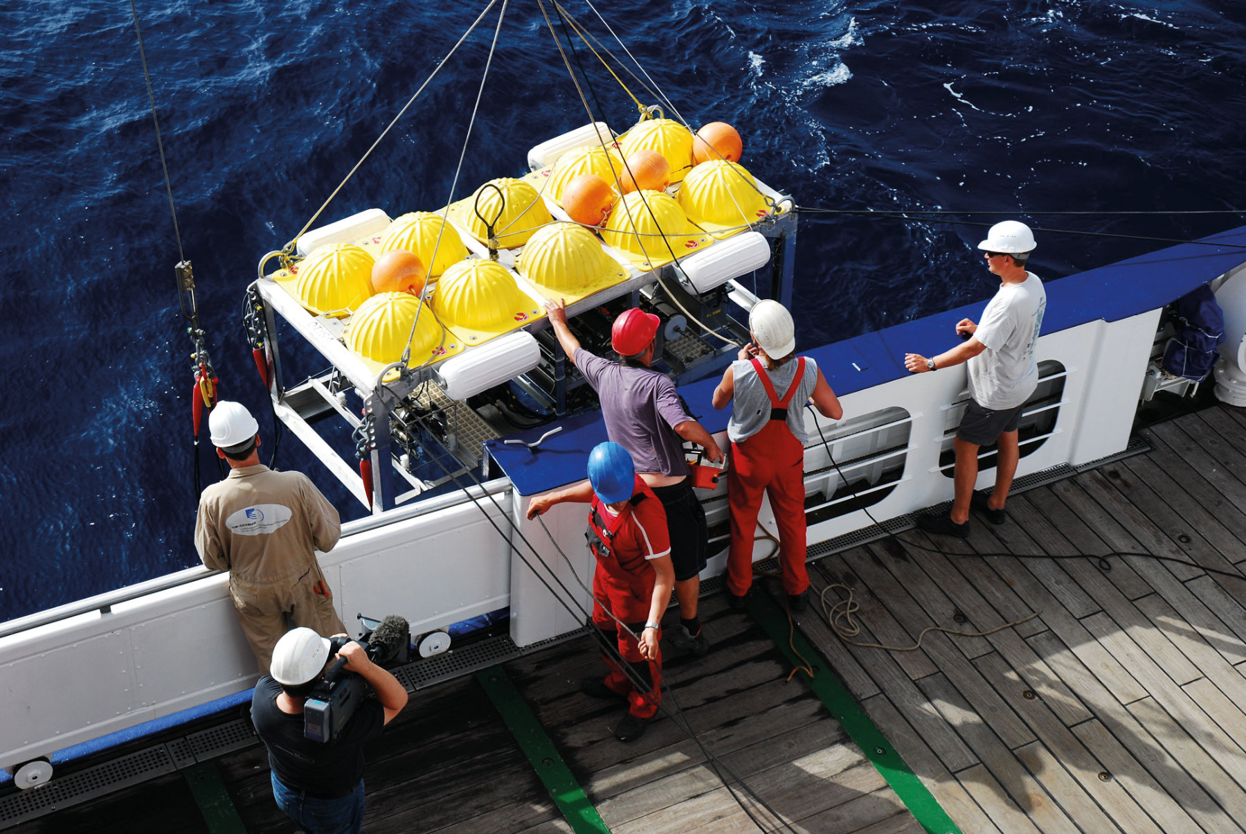
We are living in the Information Age, and nowhere more so than in our growing knowledge of the oceans. Data and information are the key to using the oceans wisely, and to keeping them healthy for the future. To help do this, data are gathered by a range of global observation networks, where they are processed, stored and analysed by specialists. There is global agreement on the importance of ocean data. In the 2016 Tsukuba Declaration on the future of science, technology and innovation, the G7 industrialized nations stated that "The health of the oceans has rightly been recognized as a crucial economic development issue." The Declaration detailed data priorities for the oceans, many of which are being pursued by researchers in Kiel. They are deeply involved in the collection, analysis, open publishing and sharing of ocean data, much of it gathered through interoperable observation systems. The Argo programme has involved the creation of a global array of 3,800 free-drifting profiling floats that measure the temperature and salinity of the upper 2000m of the ocean. It is perhaps one of the greatest success stories in physical oceanography. Arne Körtzinger, a chemical oceanographer who has pioneered oxygen measurements from Argo floats, is a member of the scientific steering group of Biogeochemical Argo, which is pushing for a fully-fledged biogeochemical Argo programme. Argo working groups including Körtzinger's group in Kiel are already developing the next generation of these marine observation robots, which will be equipped with biogeochemical sensors measuring oxygen, pH, nitrate, chlorophyll and suspended particles in the water column. A global array of floats will greatly enhance our ocean database and our knowledge of ocean behaviour. It will allow us to map these parameters on a global scale in real time, and detect even slight environmental change early on.
How can we observe the oceans, the Earth's largest and most complex habitat? How does marine research in Kiel contribute to monitoring the ocean's temperature, salinity and other vital properties, and can we find out if they are changing?
New technology allows us to measure the oceans in greater detail than ever. Oceans can be monitored from the sea surface or from space, and by new devices moving autonomously within the water or sitting at the sea floor. Kiel scientists are leaders in ocean monitoring, a task which is becoming more and more of a global priority
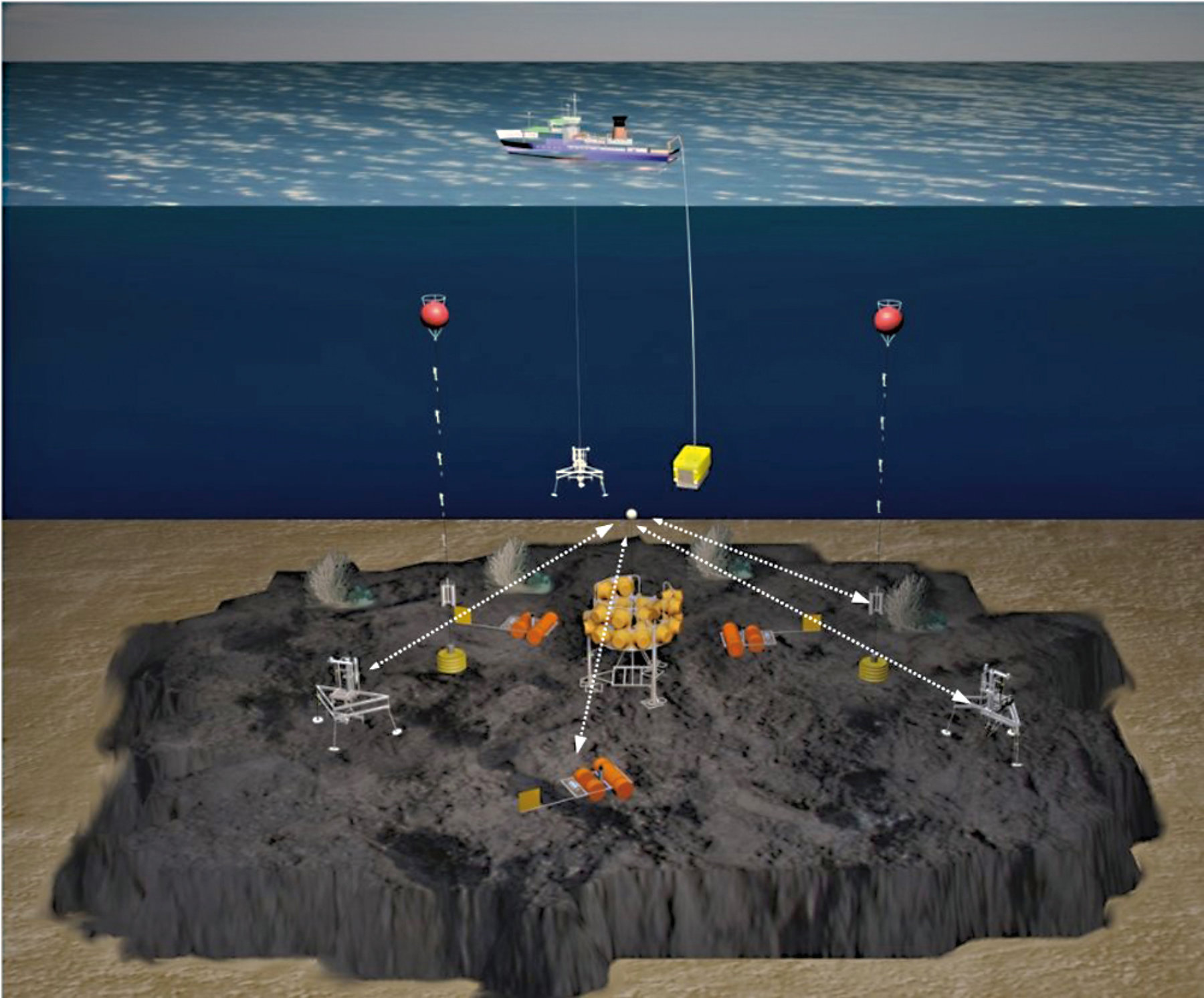
Other autonomous sensor platforms which are being employed and further extended by Körtzinger's group include Voluntary Observing Ships (VOS). These are usually merchant ships which sail stable routes across the ocean. They are equipped with sophisticated analytical instruments that measure carbon dioxide, oxygen, chlorophyll, and other parameters continuously along the same routes throughout the year. Kiel scientists are also active in more static forms of data gathering. MoLab, a seabed ocean observatory which can be left in place for months at a time to gather data from sites of scientific interest, was developed to fill the need for a fixed ocean observing system (See picture). It was first used in 2012 off the North coast of Norway, to investigate the region's cold-water coral reefs 300m below the sea surface. The Mo in MoLab means modular: different detectors can be placed at different locations across several kilometres of the sea floor, allowing a complete picture of the region to be built up. These subsystems communicate with each other by sound, so no cables need be laid on the seafloor. In the Norwegian experiment, MoLab was used to measure currents, tides, temperatures, salinity, nutrients and oxygen consumption, and the reef was observed continuously by MoLab's cameras. In this experiment, high resolution time series data and photographs from MoLab were analysed with machine learning techniques to determine the polyp activity patterns of cold-water corals [1]. The results showed that activity on the reef was governed by the strong tidal currents that prevail in that location. The coral was able to adapt to the large-scale patterns of water movement to optimize nutrient uptake. While MoLab is designed as a flexible platform for studies lasting only a couple of months, Kiel's Baltic sea researchers, including Hermann Bange, take the long view. They have maintained the Boknis Eck station since the late 1950s. Monthly sampling there began on 30 April 1957, making Boknis Eck one of the world's oldest time series sites for marine data still in operation. In December 2016 a cabled underwater observatory was deployed close to the site. It sits in 14.5 m water depth and its sensors generate continuous in-situ data. It complements the established monthly sampling at Boknis Eck and allows short-term trends and events in the western Baltic Sea to be detected.
Kiel Scientists are continuously measuring the state of the ocean on global and regional scales. They have discovered previously unknown-oxygen depleted zones within eddies in the Atlantic Ocean. These zones may play an important role in ocean productivity and biochemistry.
The Argo Program
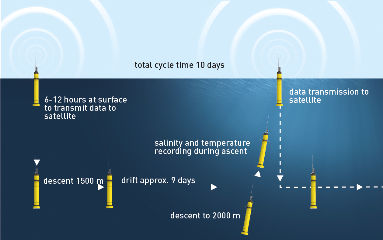
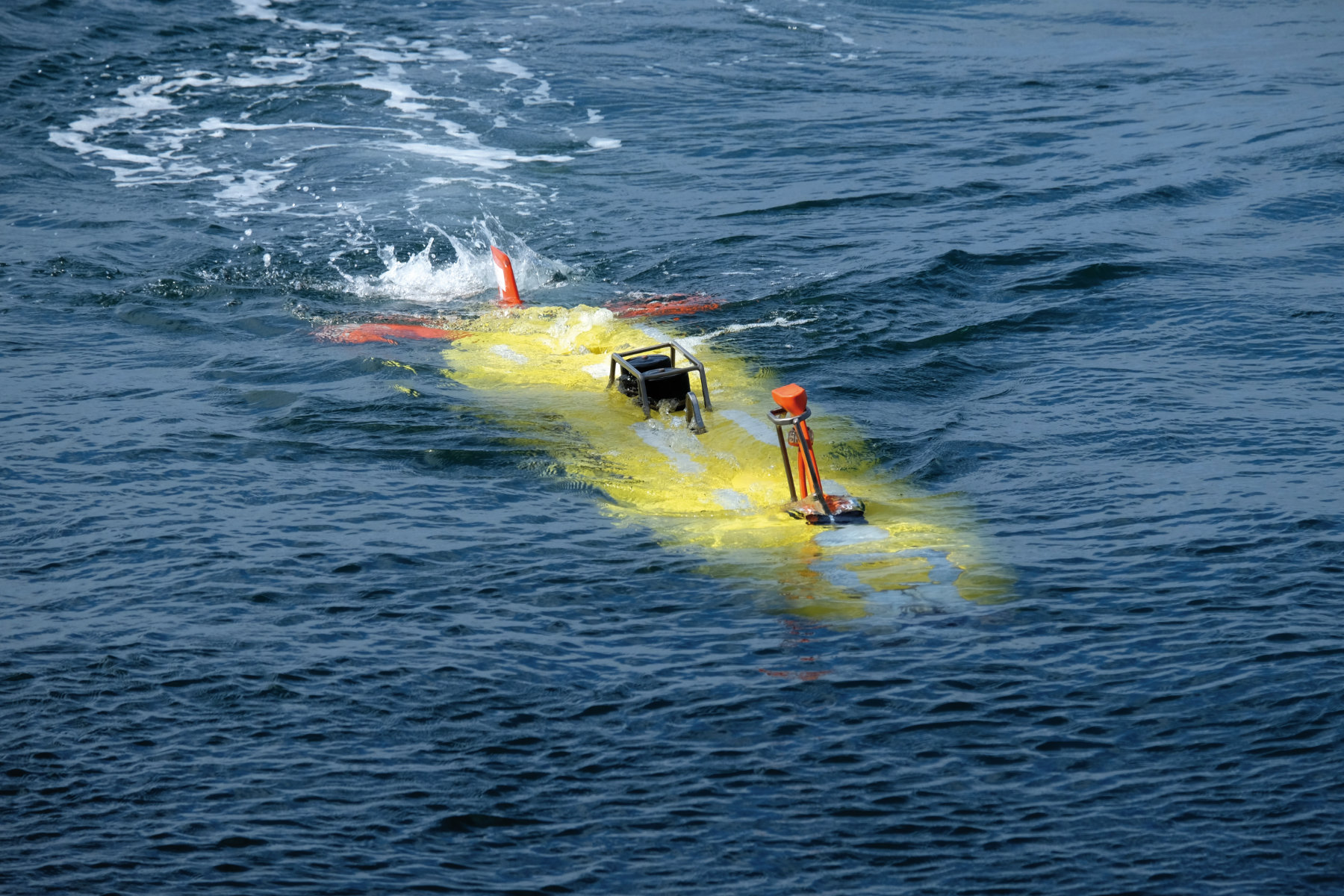
The international Argo programme deploys thousands of Argo floats in the world's oceans. The term is misleading because the Argo floats are autonomous robots which only become interesting when they sink. They can descend to 2000m below the surface by pumping oil from a bladder to modify their buoyancy. Then they ascend to the surface at predetermined times, measuring pressure, temperature and salinity in the water as they do so. At the surface, they use satellite phone technology to transmit their position and measurements to the fast-growing Argo data centres in France and the US. The floats last about four years and send data on their deep ocean dives once every ten days. About 3800 floats are in use at any one time, averaging one per 300 km of the ocean. They produce 100,000 measurements of temperature, salinity and water velocity per year. These measurements are publicly available through the data centres. See more information on the Argo programme at www.argo.ucsd.edu.
How much CO2?
Tobias Steinhoff is based at GEOMAR's chemical oceanography department. His research is concerned with carbon dioxide, the most important greenhouse gas, and how it moves between the ocean and the atmosphere. He is gathering CO2 measurements from ships crossing the North Atlantic between Europe and North America, as this is one of the most important areas in which carbon dioxide enters the ocean and is stored. He is involved in a project that aggregates these flows of data into a consistent global data product, showing the potential for big data to revolutionise our understanding of the oceans. Steinhoff is one of hundreds of scientists, based in institutions from New Zealand to Japan and Brazil, who have created SOCAT, the Surface Ocean CO2 Atlas [2]. This massive global database unites updated, quality-controlled values for the carbon dioxide concentration of global surface oceans and coastal seas from a wide range of sources. Version 5 of SOCAT was released in 2017 and contains 21.5 million values from 3646 data sets from 1957 to 2017, three million more than the fourth edition. SOCAT has made more than one million observations per year for the last decade. Each data point comes with a quality flag, allowing users to gauge the reliability of data from different sensors and platforms. SOCAT is used for vital scientific investigations, especially the quantification of the ocean sink for atmospheric carbon dioxide and its long-term variation. It also is an important input to the annually released global carbon budget [3], a key element in the compilation of the famous IPCC Climate Report.
The Atlantic's Hidden Dead Zone
The growing availability of data on the oceans has allowed Kiel researchers to find out about previously unknown dead zones of the Atlantic [4], working with colleagues in the Cape Verde Islands and elsewhere. A group involving Johannes Karstensen and Björn Fiedler discovered these oxygen-poor dead zones at the Cape Verde Ocean Observatory (CVOO) in the eastern tropical North Atlantic. They used data on dissolved oxygen in the oceans obtained from subsea gliders, moored measuring devices, research vessels, and the Argo floats mentioned above. This novel dataset reveals that dead zones are common in the tropical Eastern Atlantic. They occur within eddies, swirling water bodies of more than 100 km in diameter. 27 have been observed so far in the available data. The lowest oxygen concentrations are found just below the surface, from 50 to 150 m depth, with consequences for the marine fauna. It seems that these low-oxygen zones form because the swirling motion of the water isolates them from the rest of the ocean, while high levels of biological activity depress their oxygen content [5]. These results are important because we already know that climate change is likely to reduce the amount of oxygen in the oceans, and oxygen is important for almost all marine life. The scientists say: "In light of projected ocean deoxygenation, oxygen loss events like these eddies are already showing us how microbial communities and ecosystem structures will be altered in the future. There could be impacts on primary productivity and on biogeochemical processes in oceanic water bodies." This could have severe consequences for nations such as Cape Verde and the rest of West Africa, where national economies are heavily dependent upon fisheries.
The legal aspect of subsea robots
Subsea gliders and submersible buoys are effective at gathering data about the oceans. But many of them are drifting uncontrolled. What are the legal implications of these devices? Katharine Bork and colleagues from Kiel think they may not be well-defined. In the journal Ocean Development and International Law, they point out that coastal states have full legal rights over what happens in their territorial waters, and this includes the use of these data-gathering devices. This applies even when they were launched into the ocean far away [6], but later drift into the territorial waters of a particular nation. In addition, using floats to gather routine weather and wave data might be regarded as survey activity rather than scientific research. This puts it under the remit of a different body of international law. Bork and her co-authors say that "At the time of the negotiation of UNCLOS, the 1982 UN Law of the Sea convention that governs these activities, oceanographic surveying was not very advanced. The Argo Project, and other systematic programs, go beyond this understanding because the data collected is not for exclusive use, but is made available immediately without delay, in near real-time, to all kinds of users." But they add that "coastal states are not yet willing to modify the current legal regime on marine scientific research despite a clear need for the use of floating devices for the benefit of mankind, for example weather warnings, ship routing services, or the detection of climate change. It seems that, unlike floats and gliders themselves, their legal regime will remain firmly at anchor for the time being."
What is the future for ocean monitoring?
Sensors are improving rapidly, while Argo and other initiatives allow us to monitor large parts of the ocean on a regular basis. "The new parameters measured by the BioGeoChemical Argo will provide a breakthrough for marine biogeochemistry" predicts Arne Körtzinger.
However, gaps in our knowledge remain. Few of today's observatories target the deep sea, and even these are mostly temporary. The zone below 2000 m is only well-explored in small patches of specific interest, for instance where commercial exploration for oil or other minerals has taken place or where there are particular geological or ecological features. Most of the deep sea between the seafloor and the upper two km of water remains largely unexplored. This problem is now being addressed. New infrastructure installed at the Ocean Science Centre Mindelo (OSCM) in the Cape Verde Islands provides a modern, multifunctional platform for deep ocean assessment. Its development follows what we term the 3-Spheres Approach. This addresses the sphere of international marine research, the sphere of locally-motivated research driven by socio-economic need, and the sphere of capacity-building in the West African region. Coherent and concerted activity in all three of these spheres is one of the foremost tasks for marine science in Kiel.
References
[1] Johanson, A., Flögel, S., Dullo, W. C., Linke, P. and Hasselbring, W. (2017) Modeling Polyp Activity of Paragorgia arborea using Supervised Learning. Ecological Informatics, 39 . pp. 109-118. DOI 10.1016/j.ecoinf.2017.02.007.
[2] Bakker, D. C. E., Steinhoff, T., Körtzinger, A., et al. (2016) A multi-decade record of high-quality fCO2 data in version 3 of the Surface Ocean CO2 Atlas (SOCAT). Earth System Science Data, 8 (2). pp. 383-413. DOI 10.5194/essd-8-383-2016.
[3] Le Quéré, C., Körtzinger, A., et al. (2016) Global Carbon Budget 2016. Earth System Science Data, 8 (2). pp. 605-649. DOI 10.5194/essd-8-605-2016.
[4] Fiedler, B., Grundle, D., Schütte, F., Karstensen, J., Löscher, C., Hauss, H., Wagner, H., Loginova, A. N., Kiko, R., Silva, P., Tanhua, T. and Körtzinger, A. (2016) Oxygen Utilization and Downward Carbon Flux in an Oxygen-Depleted Eddy in the Eastern Tropical North Atlantic. Biogeosciences (BG), 13 . pp. 5633-5647. DOI 10.5194/bg-13-5633-2016.
[5] Karstensen, J., Schütte, F., Pietri, A., Krahmann, G., Fiedler, B., Grundle, D., Hauss, H., Körtzinger, A., Löscher, C. R., Testor, P., Vieira, N. and Visbeck, M. (2017) Upwelling and isolation in oxygen-depleted anticyclonic modewater eddies and implications for nitrate cycling. Biogeosciences (BG), 14 (8). pp. 2167-2181. DOI 10.5194/bg-2016-34.
[6] Bork, K., Karstensen, J., Visbeck, M. and Zimmermann, A. (2008). The Legal Regulation of Floats and Gliders—In Quest of a New Regime?, Ocean Development & International Law, 39:3, 298-328, doi: 10.1080/00908320802235338